Hazard Mitigation Plan 2025: How Geospatial Tech Saves Lives
When communities face increasing natural disasters, planning well in advance is what prevents repeated damage. The most effective hazard mitigation plans rely on geospatial technology to turn complex data into clear, actionable insights.
When communities face increasing natural disasters, planning well in advance is what prevents repeated damage. That planning centers on a hazard mitigation plan (HMP): a structured process where state, tribal, and local governments identify hazards that pose a risk, assess risks and vulnerabilities, and develop long-term strategies for protecting people and property from similar events in the future. Under the Disaster Mitigation Act of 2000 (DMA 2000) and 44 CFR Part 201, FEMA requires every state, tribal, and local jurisdiction to create and maintain a plan that identifies hazards, assesses vulnerabilities, and outlines strategies to reduce long-term risk.
Key Takeaways
- A FEMA-approved Local Hazard Mitigation Plan is required for eligibility under HMGP, BRIC, and other federal funding programs
- Plans must be updated every five years under 44 CFR § 201 to retain funding access
- Geospatial platforms replace static map-based planning with interactive, multi-hazard risk analysis, visualizing floodplains, fire perimeters, storm surge zones, and other natural hazards
- Social vulnerability overlays ensure mitigation strategies prioritize the populations most at risk
- Mobile field reporting tools keep plans grounded in real-world conditions, not just modeled estimates
- Smart Site Plan eliminates the GIS expertise barrier for small and mid-size jurisdictions, enabling preparedness, response, and recovery in one map-based environment
What the Law and Policy Actually Require
- Disaster Mitigation Act of 2000 (DMA 2000): This amendment to the Stafford Act requires state, local, and tribal governments to develop mitigation plans as a condition of receiving federal funding for certain hazard mitigation assistance programs.
- 44 CFR Part 201: FEMA’s regulation, codified in the Code of Federal Regulations, sets out the specific requirements for state, local, and tribal mitigation planning, including plan content, process, and update timelines.
- Funding eligibility: FEMA requires local jurisdictions to have an approved hazard mitigation plan under §201.6 to be eligible for Hazard Mitigation Grant Program (HMGP) funds.
- Plan update cycle: Plans must be updated every five years to remain approved and retain funding eligibility.
- Current policy: FEMA’s Local Mitigation Planning Policy Guide (FP-206-21-0002) (effective 2023) remains the authoritative document for plan requirements and review standards.
- HMA Policy and Program Guide: FEMA’s Hazard Mitigation Assistance (HMA) program outlines how mitigation actions are funded and connected to approved plans.
These frameworks ensure that local jurisdictions, tribal governments, and states can access federal funding while implementing long-term strategies to reduce the impacts of disasters, safeguard lives, and prevent repeated damage.
What does a hazard mitigation plan do?
A hazard mitigation plan identifies the natural hazards that pose a risk to people and property and outlines long-term ways to reduce those risks.
Understanding the Essentials of a Hazard Mitigation Plan
A hazard mitigation plan is more than a document; it’s a roadmap for community resilience. Under the Disaster Mitigation Act of 2000 (DMA 2000) and 44 Code of Federal Regulations (CFR) Part 201, FEMA requires every state, tribal, and local jurisdiction to create and maintain an HMP that identifies hazards, assesses vulnerabilities, and outlines strategies to reduce long-term risk.
Here’s what FEMA requires every plan to include:
- Hazard Identification: Define the hazards that pose a risk—from floods and earthquakes to wildfires and tornadoes.
- Risk Assessment: Evaluate how those hazards affect people and property, using data on exposure, frequency, and potential losses.
- Mitigation Strategy: Set mitigation goals and list specific mitigation actions, such as infrastructure improvements, buyouts, or public awareness campaigns, to reduce long-term impacts.
- Plan Maintenance: Describe how the jurisdiction will update the plan every five years, keeping it relevant as risks evolve.
To qualify for federal funding, local jurisdictions must have a FEMA-approved plan in place. Without it, they can’t access programs like the Hazard Mitigation Grant Program (HMGP) or Building Resilient Infrastructure and Communities (BRIC).
FEMA also emphasizes that planning should be inclusive. A hazard mitigation steering committee, composed of local officials, emergency managers, public works leaders, utilities, and community representatives, helps ensure the plan reflects real risks and realistic solutions.
At its core, mitigation planning is about foresight: identifying these risks now, so communities can develop long-term strategies for protecting people and property from similar events later.
What is an example of hazard mitigation?
An example of hazard mitigation is elevating flood-prone homes or strengthening critical infrastructure to reduce risk and safeguard lives.
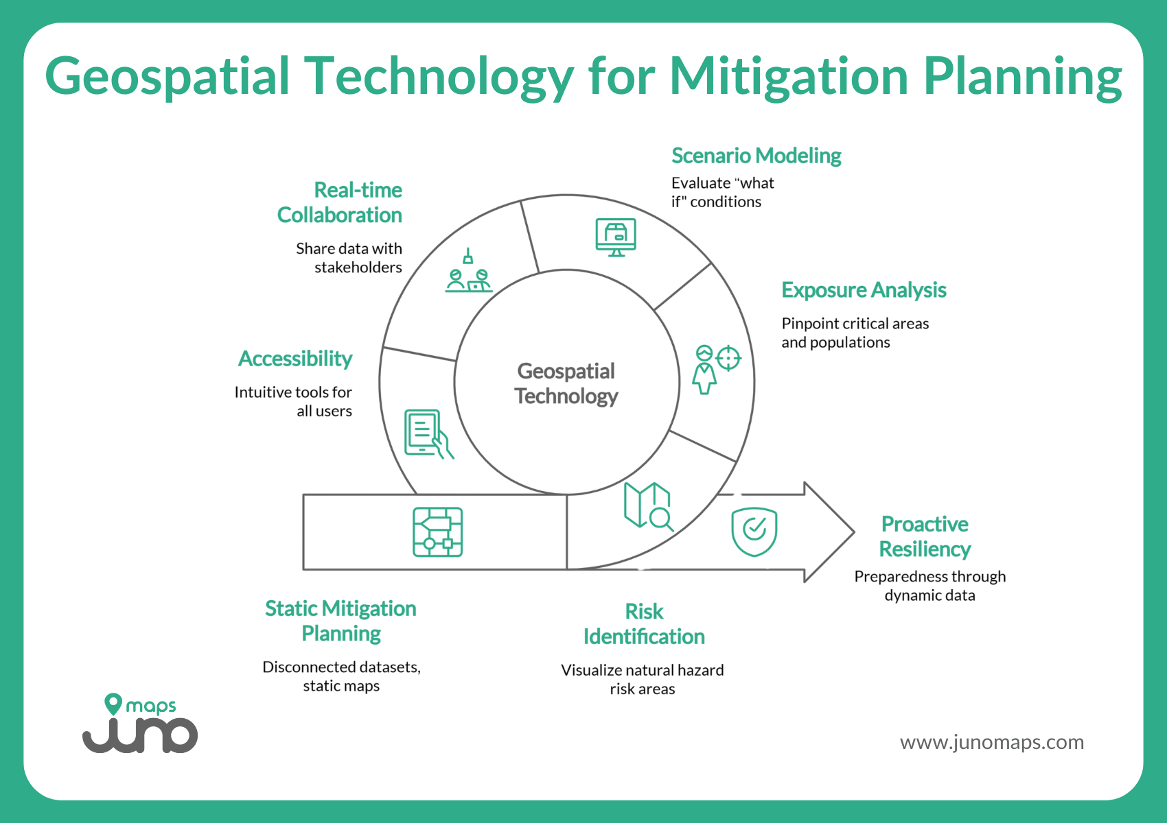
Why Geospatial Technology Matters in Modern Mitigation Planning
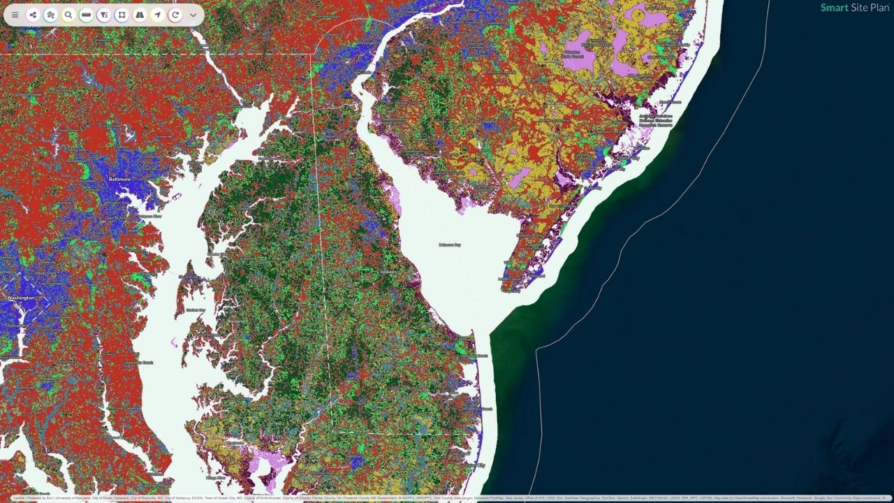
Historically, mitigation planning depended on static maps and disconnected datasets. Today, the complexity of hazards – flooding, wildfire, hurricanes, tornadoes, earthquakes – demands a more dynamic approach.
Geospatial technology bridges that gap by connecting data across agencies and transforming it into an interactive map that supports each phase of the planning process.
- Risk identification: Visualize floodplains, fire perimeters, storm surge zones, and other natural hazards that pose a risk.
- Exposure analysis: Overlay infrastructure, utilities, and socially vulnerable populations to pinpoint critical areas.
- Scenario modeling: Use elevation, soil, and infrastructure data to evaluate “what if” conditions and plan mitigation actions that make the most impact.
- Real-time collaboration: Share maps and data with stakeholders, enabling rapid coordination among emergency management, public works, and utilities.
- Accessibility: No GIS expertise is required; intuitive tools make the data useful to planners, engineers, and community leaders alike.
This approach not only supports FEMA’s Risk MAP and HMA programs but also helps jurisdictions achieve a truly proactive level of resiliency and preparedness.
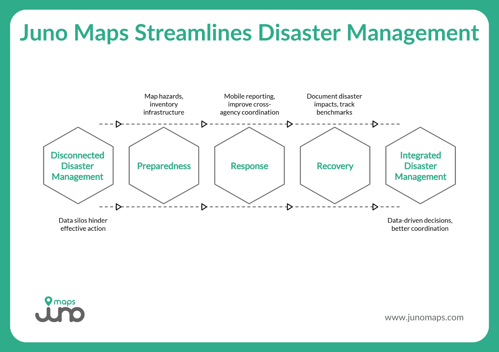
How Juno Maps Supports the Entire Cycle
Turning a hazard mitigation plan into real-world action requires more than compliance; it takes tools that connect data, people, and decisions at every stage of the disaster management cycle. That’s exactly what Juno Maps delivers. Through its flagship platform, Smart Site Plan, Juno Maps equips local governments, tribal agencies, utilities, and emergency management teams with the ability to plan, prepare, respond, and recover, all within one intuitive, map-based environment.
Smart Site Plan transforms the traditional, document-heavy planning process into a living, collaborative workspace. Decision-makers can visualize hazards, overlay social vulnerability data, and prioritize mitigation projects in real time. Field teams can report damage through geo-tagged photos, while planners can monitor long-term recovery progress, all without needing specialized GIS expertise.
Preparedness
- Map multi-hazard exposure zones and overlay social vulnerability indexes to identify at-risk populations.
- Maintain critical infrastructure inventories and develop interactive maps of mitigation strategies.
- Harmonize data from spreadsheets, CAD files, remote sensing, and open data sources.
- Enable mobile-first field reporting with geo-tagged photos and inspection forms.
- Improve cross-agency coordination through property-linked maps and real-time updates.
- Visualize damage and resource allocation across jurisdictions instantly.
- Document disaster impacts at the parcel level for FEMA reimbursements or HUD grants.
- Track long-term recovery benchmarks, from housing repair to green infrastructure integration.
- Archive all data and maps to speed up future disaster response and plan updates.
By removing the GIS barrier, Smart Site Plan empowers authorities to plan, respond, and rebuild smarter, aligning with FEMA’s focus on reducing loss of life and property through better coordination.
Best Practices for Building a Defensible, Data-Driven Hazard Mitigation Plan
A hazard mitigation plan is only as strong as the process behind it. To stand up to FEMA review and truly guide long-term resilience, each plan must be grounded in reliable data, clear documentation, and community collaboration. A defensible mitigation plan doesn’t just identify risks; it shows exactly how a jurisdiction gathered, verified, and used its data to make informed decisions.
By following a few key best practices, communities can create a plan that’s both technically sound and locally supported, ensuring it meets FEMA’s standards while driving real-world impact.
These practices maintain a collaborative, defensible, and FEMA-ready planning process, while fostering trust and transparency throughout your jurisdiction.
Who prepares a hazard mitigation plan?
The planning process typically begins with the state and involves coordination among local jurisdictions, tribal governments, and city agencies.
Smarter Maps, Safer Communities
An effective local hazard mitigation plan isn’t a document; it’s a living strategy. By embracing geospatial technology, communities move from reactive recovery to proactive prevention.
FEMA requires the plan; geospatial tools make it work. With accurate data, collaborative mapping, and intuitive software like Smart Site Plan, your jurisdiction can strengthen its preparedness, protect people and property, and build resilience that lasts.
Ready to build a smarter hazard mitigation plan? Explore how Juno Maps can help your team identify risks, coordinate across departments, and safeguard lives, long before the next storm, flood, or fire arrives. Get in touch today!
Ready to Put This Into Practice?
See how Juno Maps applies to your specific industry and use case.