Before You Build: What Floodplain Maps Reveal About Risk and Safety
Learn how to find, read, and apply floodplain maps before breaking ground. Understand FEMA flood zones, 100-year vs 500-year risk, and modern GIS tools.
Before you break ground on any project, one tool should be at the top of your checklist: floodplain maps. These maps reveal where flooding is likely to occur, how severe it could be, and what it means for your design, construction timeline, and long-term maintenance costs. For contractors, designers, government teams, and project owners, understanding flood risk early helps you bid smarter, plan faster, and avoid expensive surprises later.
Key Takeaways
- Floodplain maps identify areas with a higher likelihood of flooding based on terrain, rainfall, drainage, and historical flood events
- FEMA's Flood Insurance Rate Maps (FIRM) show flood zones, base flood elevations, and Special Flood Hazard Area boundaries used for permitting and insurance decisions
- A "100-year flood zone" means a 1% annual chance of flooding, not a once-per-century event, which compounds significantly over a building or infrastructure lifespan
- The 500-year floodplain (0.2% annual chance) still carries real design and maintenance implications and should be reviewed for long-term infrastructure projects
- Traditional flood map systems, static PDFs, multiple portals, limited mobile access, slow down teams working in fast-moving project environments
- Geospatial tools like Smart Site Plan centralize floodplain maps, utilities, parcel data, and project files into one mobile-ready platform for faster, smarter decisions
What Is Floodplain Mapping and Why It Matters
Floodplain mapping identifies areas with a higher likelihood of flooding based on terrain, rainfall, drainage, and historical flood events.
In the U.S., most official flood maps come from the National Flood Insurance Program (NFIP) administered by the Federal Emergency Management Agency. These Flood Insurance Rate Maps (FIRM) show flood zones, base flood elevations, and Special Flood Hazard Area boundaries that local governments use for floodplain management and that insurers and lenders use for flood insurance and lending decisions.
For contractors and designers, floodplain mapping influences:
- Site feasibility
- Permit approvals
- Construction methods
- Risk assessments
For government agencies, it supports asset management, infrastructure planning, and community safety. For owners, it provides the data needed to make faster decisions and avoid costly surprises.
How to Find Floodplain Maps and Flood Risk Information
If you need to find floodplain maps, start with FEMA's Flood Map Service Center. This official map service allows users to search by address and view flood zones, DFIRM data, and regulatory maps.
Most local governments also maintain mapping portals where you can view:
- Community flood maps
- Preliminary or advisory updates
- Drainage and levee information
- Construction requirements
Your local floodplain administrator can provide additional flood risk information and regulatory guidance for your specific site.
Interactive Flood Map Tools and Systems
Many agencies now offer interactive map systems that allow users to:
- Enter a property address
- View flood hazard layers
- Download official maps
- Check updates
However, these systems often exist across multiple websites and databases, making it difficult for project teams to access everything in one place, especially from the field.
How to Read a Floodplain Map Before You Build
Knowing how to read a floodplain map before a project begins can save you time, protect your budget, and prevent major surprises once work is underway.
These maps aren't just regulatory paperwork. They offer practical insight into site conditions, construction requirements, and long-term risk. When you know what to look for, they become a powerful planning tool for everyone involved.
Key Flood Map Elements to Review
Start by focusing on the details that directly impact your site and scope of work. Most official flood maps include layers and symbols that highlight critical risk factors. Pay close attention to:
- Flood zone designation
- Base Flood Elevation (BFE)
- Floodway boundaries
- Drainage infrastructure
- Nearby levees, waterways, or coastal flood areas
One important clarification: a "100-year flood zone" does not mean flooding happens once every century. It means there is a 1 percent chance of flooding in any given year. That probability adds up over time, especially for infrastructure and buildings designed to last decades. Understanding this distinction helps teams evaluate risk more realistically.
What Flood Maps Reveal About Project Risk
Flood maps do more than outline boundaries. They help you anticipate how a site will perform under real-world conditions and what requirements you may need to meet before construction can move forward. From a planning standpoint, they can reveal:
- Whether flood insurance policies may be required
- Elevation or construction standards tied to the site
- Long-term flood hazard risk
- Potential exposure to water damage or drainage issues
For contractors, this information shapes bids, timelines, and site logistics. For government agencies, it supports infrastructure planning and emergency preparedness.
When teams take the time to read flood maps accurately, they gain a clearer picture of site risk and can make smarter, faster decisions before work begins.
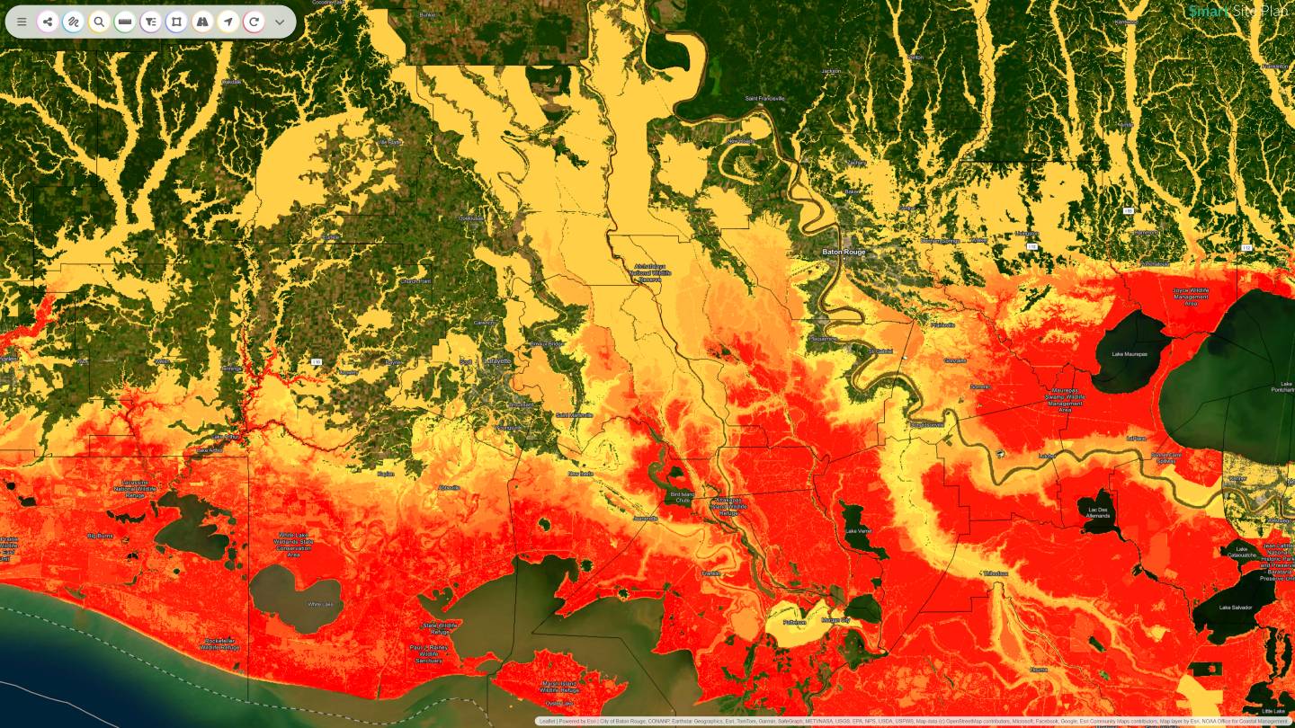
Understanding the 100-Year and 500-Year Floodplain Map
Most teams are familiar with the 100-year floodplain, but the 500-year floodplain map is just as important when you're thinking long term. A 500-year floodplain identifies areas with a 0.2 percent annual chance of flooding. These zones are often labeled as moderate risk, yet they still carry real implications for design, construction, and maintenance.
It's easy to assume that only high-risk flood zones matter. In reality, flooding doesn't always stay within neat boundaries.
Why Floodplain Maps Matter for Your Project
Several factors make it essential to review both 100-year and 500-year floodplain maps before you build:
- Climate patterns and development can shift flood behavior. As land use changes and storm intensity increases in some regions, flood boundaries can expand or evolve.
- Infrastructure is built to last. Roads, utilities, and buildings are expected to perform for decades. Planning only for today's minimum standards may not protect against future conditions.
- Moderate-risk areas can still experience flooding. Drainage issues, overwhelmed systems, or unexpected storm events can affect areas outside the primary floodplain.
Looking at both the 100-year and 500-year floodplain maps gives teams a more complete picture of flood risk. Instead of planning only to meet basic regulatory requirements, many organizations now evaluate moderate-risk areas as part of a smarter, forward-thinking approach to site planning and safety.
Why Traditional Flood Map Systems Fall Short
Official flood maps are essential. They provide the regulatory backbone for permitting, insurance requirements, and site planning. But for today's contractors, designers, government teams, and project owners, the way that flood map information is delivered often hasn't kept up with how projects actually move.
Most teams are working in fast, collaborative environments where decisions happen in real time. When flood risk data lives in disconnected systems, it slows everything down.
Common Traditional Flood Map Limitations
Traditional flood map systems often come with challenges such as:
- Static PDF maps that are difficult to navigate
- Multiple websites and portals that house different layers of information
- Limited mobile access for field teams
- Delayed updates or preliminary maps that are hard to track
- Complex layers that require technical expertise to interpret
Imagine a contractor standing on site trying to confirm flood risk. They may need to open a flood map on one device, reference CAD drawings on another, and check inspection notes separately just to understand the conditions around them.
The goal isn't to replace official flood maps. It's to make them more usable. When floodplain data is centralized, accessible, and updated in real time, teams can move forward with confidence. They can spot risks earlier, coordinate more effectively, and keep projects on track.
Using Geospatial Tools to Improve Floodplain Awareness
Traditional flood maps often live on a government website or in downloadable PDFs. While these are essential regulatory resources, they don't always support real-time project workflows. Geospatial tools bridge that gap by bringing multiple data sources together.
Today's mapping tools can integrate:
- CAD files and site plans
- GIS layers and floodplain maps
- Open data from government databases
- FEMA flood map information
- Location-based site data
Instead of searching multiple websites to find flood risk information, teams can enter an address or location and view everything in one place. Many platforms connect directly to official mapping programs and web-based databases, allowing users to access flood hazard information online with greater speed and clarity.
The goal isn't just to access flood maps. It's to use them in a way that supports smarter decisions. When floodplain mapping tools bring together official data, project files, and real-time collaboration, teams gain a clearer picture of their flood risk and can act on it quickly.
Before You Build: Questions to Ask About Flood Risk
The earlier you confirm flood risk information, the smoother your project will move. Too often, teams discover flood zone requirements halfway through design or during permitting, which can lead to delays, redesigns, and unexpected costs. Taking time upfront to gather accurate floodplain data helps contractors bid more confidently, designers plan more efficiently, and owners avoid last-minute surprises.
What Teams Should Confirm Early
Before committing to a site or finalizing plans, confirm the fundamentals. Start by reviewing official flood map information and verifying the latest available data. Teams should ask:
- Is the site located in a floodplain or designated flood zone?
- Are there preliminary or advisory updates to the flood maps?
- How current is the available flood risk data?
- Who maintains the flood map information for this area?
- Are there local drainage or infrastructure considerations not shown on national maps?
Flood maps can change as new studies are completed or as infrastructure evolves. Checking for updates ensures you're working with the most accurate information possible. This is especially important for long-term infrastructure projects, where even moderate changes in flood risk can affect design and permitting.
How Juno Maps Supports Smarter Floodplain Planning
When flood risk data sits across PDFs, government websites, and separate design files, teams lose time and risk missing key details. Smart Site Plan from Juno Maps brings that information together so contractors, designers, government teams, and owners can see the full picture in one place.
The platform centralizes floodplain maps, utilities, parcel data, and project files into a single, mobile-ready system. Teams can pull up accurate site information from anywhere, whether they're in the field, at the office, or reviewing plans with stakeholders. Instead of switching between systems, everyone works from the same data in real time.
This connected approach helps:
- Reduce rework by identifying risks earlier
- Improve site awareness with georeferenced maps
- Speed up reporting, inspections, and communication
- Keep project files and updates in one accessible location
Smart Site Plan also integrates CAD and GIS files, open data, and mapping layers so floodplain information sits alongside everything else that matters to a project. When teams can see flood risk in context, they can bid smarter, plan faster, and avoid costly surprises.
Build Smarter with Better Data
Floodplain maps are more than regulatory documents. They are planning tools that reveal hidden risks and guide safer construction decisions. By learning how to find, read, and apply flood map data, teams can reduce damage, improve safety, and build smarter.
And with modern geospatial tools, accessing accurate flood risk information is easier than ever.
Ready to understand your flood risk before your next project begins? Start with the right data, the right maps, and the right tools. Contact us to learn more!
How are flood maps updated, and what are the timelines?
Flood maps are updated by FEMA in coordination with state, tribal, and local partners when new flood studies, topographic data, or significant land-use changes justify a revision. The end-to-end process is typically a multi-year effort.
How do I change my flood zone designation?
You can request a Letter of Map Amendment (LOMA) or a type of Letter of Map Revision (such as a LOMR or LOMR-F) from FEMA.
Where can I find information on map amendments and revisions?
Check FEMA's Flood Map Service Center, which provides access to current effective FIRMs and Letters of Map Change, or contact your local floodplain administrator.
Ready to put this into practice?
See how Juno Maps applies to your specific industry and use case.