Geospatial Intelligence · Business Intelligence

Turn Complex Data
Into Confident Action.

Juno Maps builds two purpose-built asset management platforms. Smart Site Plan manages physical infrastructure in the field. Green Pulse HQ manages business knowledge in the office. Both give you the intelligence to outperform.

SOC 2 InfrastructureAES-256 EncryptedGlobal Deployment99.9% Uptime

Trusted by government agencies, engineering firms, and utilities worldwide

Brookfield ResidentialCushman & WakefieldPerdueBLEWRAUCH IncSDC Capital Partners
Two Platforms

Every Advantage, Purpose-Built

One company. Two best-in-class asset management platforms. Deploy either independently or together.

Geospatial Intelligence

Smart Site Plan

Cloud GIS for government agencies, utilities, and infrastructure teams that need spatial asset management without a dedicated GIS department.
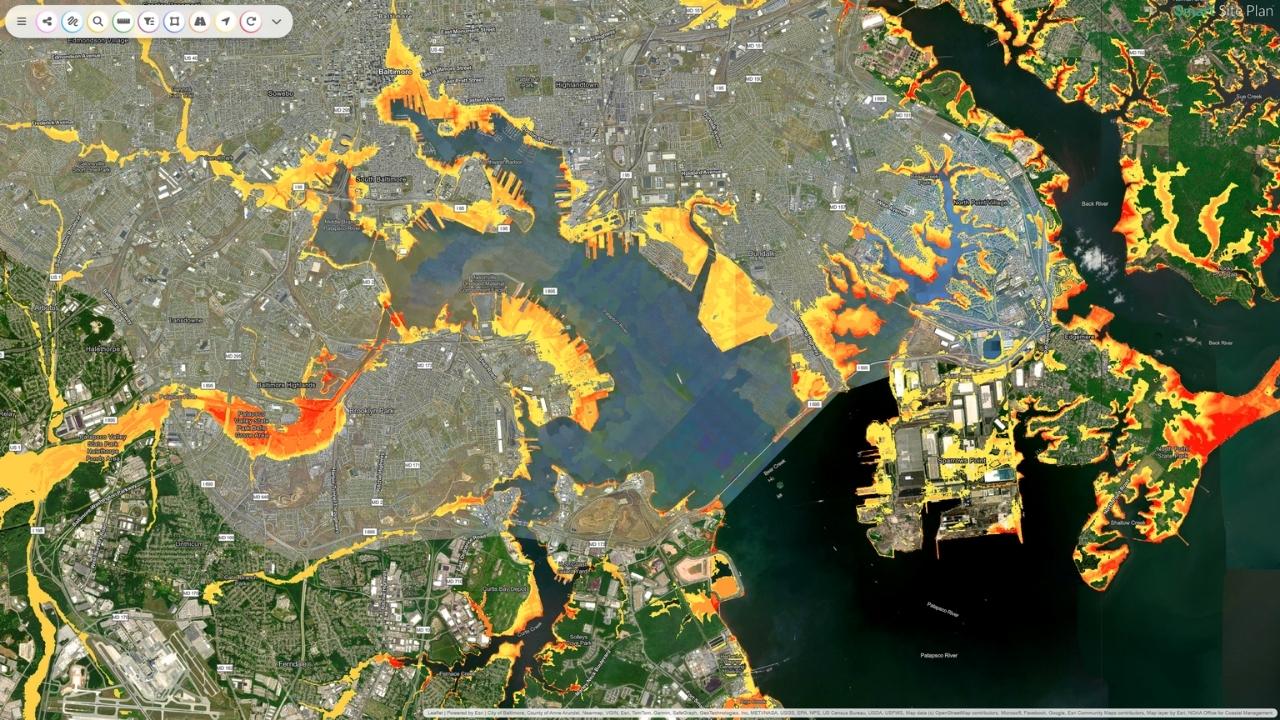
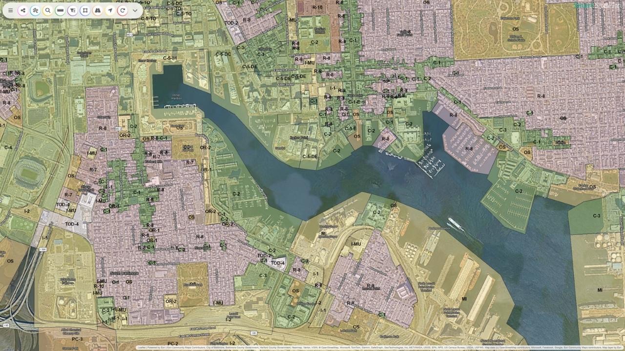
  • 18M+ curated geospatial datasets from authoritative global sources
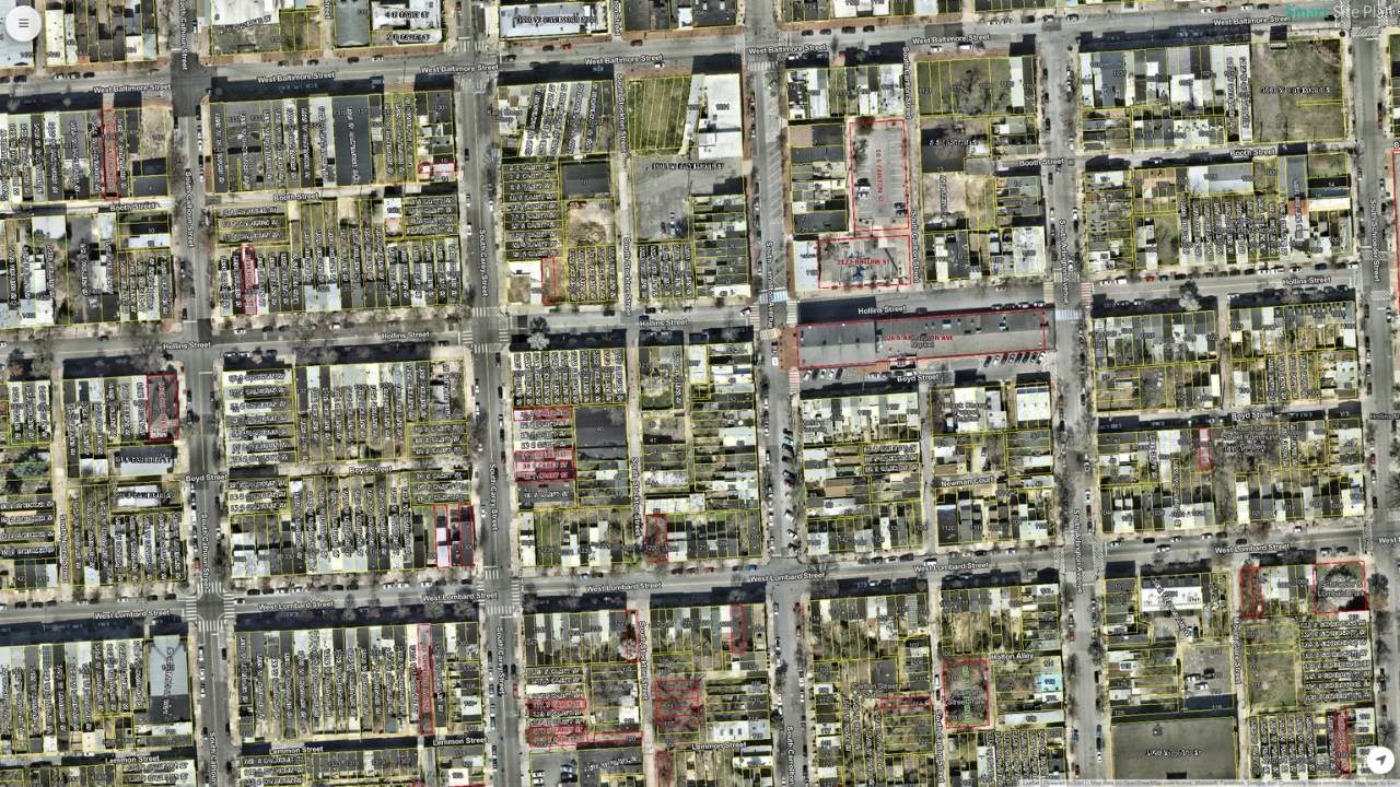
  • CAD, GIS, and live field data unified on one map
  • Mobile inspection forms with real-time sync and geo-stamping
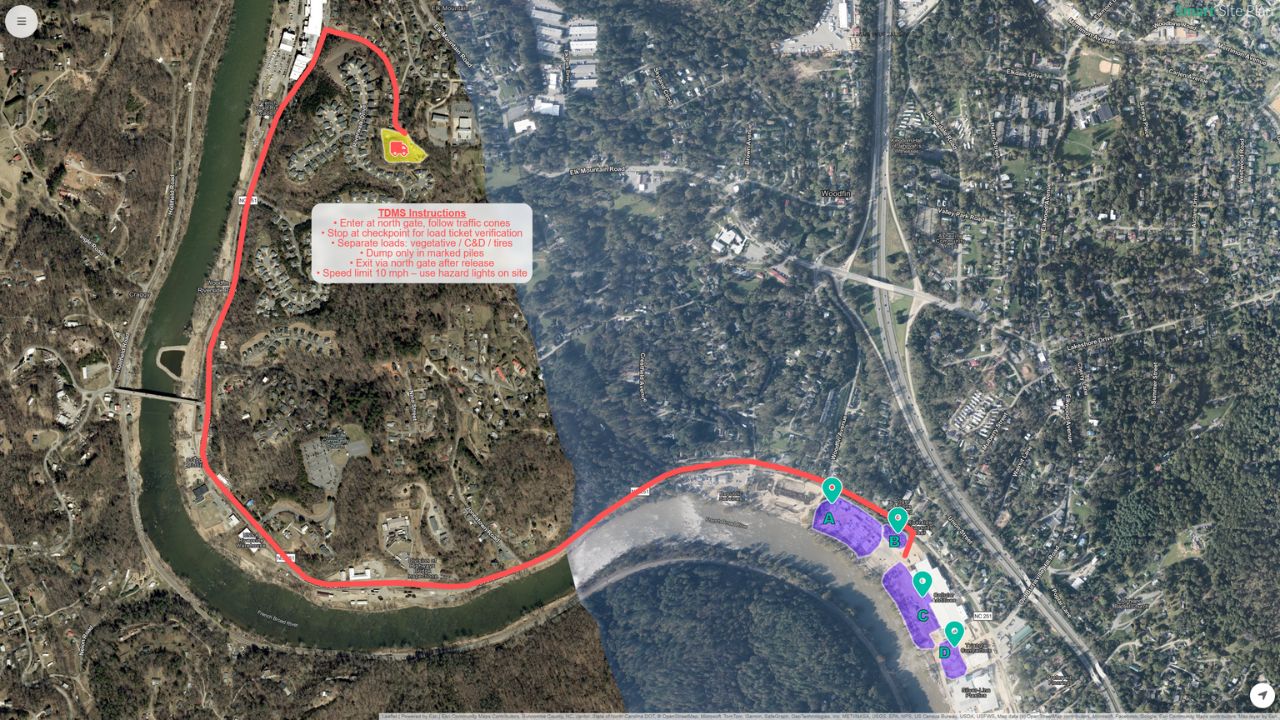
  • EPA, FEMA, and federal compliance workflows built in
Explore Smart Site Plan
Business Intelligence

Green Pulse HQ

Business intelligence platform that organizes your company's knowledge assets and delivers the right insight at the right moment — briefings, answers, and team-wide context on demand.

  • Business briefings grounded in your company's own documents and data
  • Personalized morning briefings before your first meeting
  • Talk, type, upload, or send voice memos — zero friction
  • AES-256 encrypted, SOC 2 infrastructure, zero training policy
Visit Green Pulse HQ

2022

Founded

20M+

Datasets Integrated

8+

Industries Served

2

Platforms Built

What We Do

Built for Organizations That Run on Complex Data

Whether you manage underground infrastructure, emergency response operations, or enterprise business knowledge, Juno Maps eliminates the gap between the data you have and the decisions you need to make.

Manage Every Asset

Whether your assets are parcels, pipes, and field infrastructure or documents, data, and team knowledge — Juno Maps keeps everything organized, accessible, and actionable in one place.

Drive Compliance

Meet EPA, FEMA, and federal infrastructure mandates with purpose-built compliance workflows, auditable documentation, and reporting tools built directly into operational platforms.

Gain Strategic Intelligence

Surface the right information at exactly the right moment. Proactive briefings, contextual answers, and knowledge management that keep every team three steps ahead of the competition.

Who We Serve

Sectors That Depend on Operational Intelligence

From municipal planners to field crews, from utility compliance managers to emergency operations directors, Juno Maps builds for the organizations where data drives real decisions.

Government

Water Utilities

Engineering

Public Works

Construction

Energy

Real Estate

Emergency Mgmt

Business Intelligence

Green Pulse HQ Capabilities

Not another dashboard. A strategic intelligence layer that understands your business, anticipates what you need, and delivers before you think to ask.

Strategic Briefings

Personalized daily briefings delivered before your first meeting. Key metrics, urgent tasks, competitive signals, and strategic context — all in one place.

Business Intelligence

Ask complex questions and get answers grounded in your company's own documents and data — not generic internet knowledge — surfaced in seconds.

Knowledge Management

Upload PDFs, spreadsheets, and presentations. The platform indexes and references every document, transforming scattered files into a single source of truth.

Team Intelligence

Role-based access and shared context keep every team member operating from the same strategic picture — from the C-suite to the front line.

Enterprise Security

AES-256 encryption, SOC 2 infrastructure, and a zero training policy. Your data is never used to improve models or shared with anyone. Full stop.

Multi-Modal Input

Talk, type, upload files, or send voice memos. Green Pulse HQ meets you where you are — no rigid forms, just the fastest path to the answer you need.

Quantify Risk Before Disaster Strikes

Juno Maps delivers hazard-specific geospatial intelligence, integrating FEMA, NOAA, and federal risk datasets to help emergency managers and planners model exposure, prioritize mitigation, and coordinate response with spatial precision.

Disaster Resilience Solutions
Lead Service Lines

Meet EPA and LCRI Compliance Deadlines with Confidence

Water systems facing Lead and Copper Rule Improvements mandates need more than a spreadsheet. Juno Maps gives utilities a map-based inventory platform that accelerates record digitization, structures EPA-required documentation, and keeps compliance status visible to every stakeholder.

  • Digitize and geo-reference historical service line records, replacing manual paper processes with a structured, auditable workflow.
  • Generate EPA-compliant inventory reports and status documentation directly from your operational data, reducing reporting burden and audit risk.
  • Track material classifications, replacement progress, and notification obligations on an intuitive map interface accessible to field crews and administrators.
Explore Lead Service Line Software
Lead service line compliance and water safety management

Frequently Asked Questions

What does Juno Maps do?

Juno Maps builds two asset management platforms. Smart Site Plan delivers geospatial intelligence for government agencies, water utilities, and infrastructure organizations — replacing paper workflows and siloed GIS data with a single cloud-based platform. Green Pulse HQ delivers business intelligence for enterprise teams, turning company documents and data into contextual answers, proactive briefings, and team-wide insight.

Which organizations does Juno Maps serve?

Smart Site Plan is deployed by municipalities, state and federal agencies, water systems subject to EPA and LCRI regulations, civil engineering firms, emergency management offices, and utilities across energy, water, and public works sectors. Green Pulse HQ serves business teams of any size that need to make faster, better-informed decisions without adding overhead.

What is Green Pulse HQ?

Green Pulse HQ is a business intelligence platform that learns your organization's knowledge inside out. Upload your company documents — PDFs, spreadsheets, presentations — and the platform builds a knowledge base that powers contextual answers, personalized morning briefings, and team-wide intelligence. Built on AES-256 encrypted, SOC 2 compliant infrastructure with a zero training policy.

How does Juno Maps ensure data accuracy and reliability?

Our platforms integrate real-time geospatial datasets from authoritative federal, state, and local sources, including FEMA NFHL, EPA inventories, NOAA, and open government data. Continuous validation keeps operational records current and defensible for regulatory and field use.

How do we get started with Juno Maps?

Contact our team to schedule a focused consultation. We assess your current data environment, compliance obligations, and operational requirements before recommending the right platform and deployment path. No obligation and no generic demos.