High Resolution Satellite Imagery: Turning Aerial Data into Actionable Insight
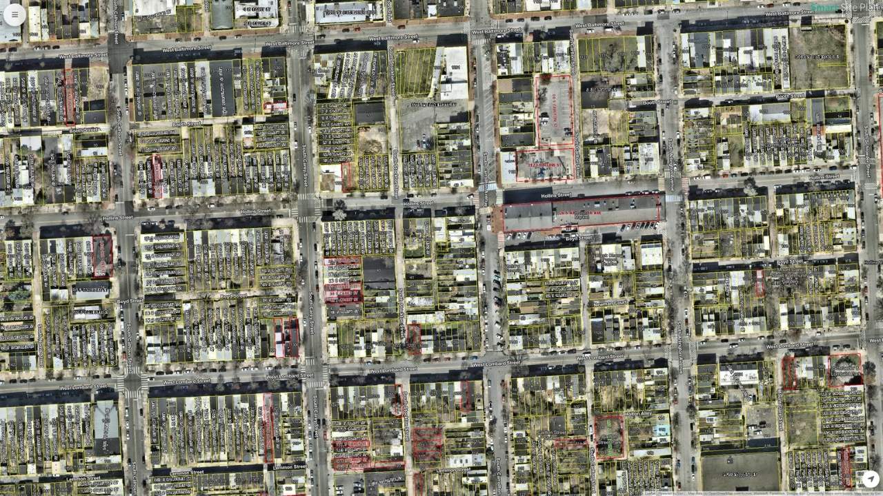
When decisions need to happen quickly, static maps, spreadsheets, and PDFs can only take you so far. High-resolution satellite imagery provides real-world context that turns each image into a living map for local governments, emergency managers, planners, and utilities.
When decisions need to happen quickly, static maps, spreadsheets, and PDFs can only take you so far. Today's projects and emergency responses move faster when teams can see what's happening on the ground. High-resolution satellite imagery provides real-world context that a table or text document cannot, offering a current view of conditions across an entire area of interest in a single, shared perspective. Instead of guessing or piecing together disconnected files, satellite imagery turns each image into a living map.
Key Takeaways
- High-resolution satellite imagery means clearer detail per pixel, allowing teams to distinguish roads, buildings, land cover, and vegetation across a defined area of interest
- Spatial resolution, update frequency, and coverage area are the three key factors professionals consider when selecting imagery
- Public sources like USGS EarthExplorer, Landsat, and Sentinel-2 provide free imagery for planning and broad analysis
- Near real-time imagery from NASA Worldview supports time-critical uses like floods and wildfires
- Commercial providers deliver sub-meter imagery for asset-level detail, damage verification, and detailed inspections
- A repeatable 5-step workflow (start with the decision, choose imagery, add context layers, validate in the field, share updates) turns imagery into actionable insight
- Emergency response, urban planning, infrastructure management, environmental monitoring, agriculture, and construction are key use cases
- Smart Site Plan by Juno Maps turns imagery, maps, and project files into a shared, decision-ready workspace
What Is High Resolution Satellite Imagery and Why It Matters
Spatial Resolution Basics
When professionals talk about resolution satellite imagery, they usually mean a balance of three things:
- Spatial resolution: How much ground each pixel covers (for example, 10-meter resolution from Sentinel-2, or 1 meter and finer from some commercial imagery).
- Update frequency: How often new imagery is available. Programs like Sentinel-2 (two satellites in orbit) revisit many areas every 5 days, supporting up-to-date views.
- Coverage area: How much land a single image captures, measured in sq km, useful for regional planning.
Which satellites and sensors provide high-resolution imagery?
High-resolution imagery comes from satellites like WorldView, Pleiades, Sentinel-2, and Landsat, using optical, multispectral, and panchromatic sensors.
What Factors Affect the Spatial Resolution?
Spatial resolution describes how much detail a satellite image can show on the ground. Several practical factors influence how sharp or detailed satellite imagery appears:
- Satellite altitude and orbit: Satellites closer to Earth generally capture higher-resolution imagery than those in higher orbits.
- Sensor design and quality: The size of the sensor, detector technology, and optics all affect how much detail each pixel can capture.
- Pixel size (ground sampling distance): Smaller pixels represent smaller ground areas, resulting in higher spatial resolution.
- Type of sensor used: Panchromatic sensors usually provide higher spatial resolution than multispectral sensors, which balance detail with spectral information.
- Viewing angle: Images taken straight down (nadir view) are typically clearer than images captured at an angle.
- Atmospheric conditions: Cloud cover, haze, smoke, and dust can reduce image clarity even when resolution is technically high.
- Data processing and compression: How imagery is processed, corrected, and compressed can impact final image sharpness.
Understanding these factors helps teams choose imagery that matches their planning, analysis, or response needs.
Satellite Imagery vs Other Aerial Imagery
Different imagery products serve different workflows:
- Satellite imagery (Earth observation): Wide coverage, consistent historical data, strong for GIS, mapping, and trend analysis. Examples include Landsat (via USGS EarthExplorer), Sentinel (Copernicus/ESA), and NASA Worldview.
- Aircraft imagery: Higher resolution over smaller areas, often used for engineering and urban projects.
- Drone imagery: Ultra-detailed, site-specific, best for close inspections.
Many teams combine satellite data, multispectral satellite imagery (RGB, near-infrared, red edge), and aerial sources to get the right insight at the right scale.
What are historical satellite images?
Historical satellite images are archived images captured over time that show past conditions of the same location for comparison and analysis.
How to Get High-Res Satellite Images (Practical Options Teams Actually Use)
If you’re looking for high-resolution satellite imagery that fits real workflows, these are the options teams use most often, from free satellite baselines to commercial detail for tight sites.
Option 1: Public and Open Imagery Sources
Great for planning, context, and long-term trends across a U.S. or regional area of interest.
- USGSEarthExplorer lets you search and download satellite data and aerial photos by AOI, date, and sensor.
- Landsat archives (including Landsat and MODIS) provide decades of historical coverage at moderate res (often low resolution to mid-range), useful for land cover, geological context, and change over time.
- Sentinel-2 offers free high resolution data (about 10–20 m) with frequent revisits, strong for vegetation, water, and environmental monitoring.
Best for: Basemaps, history, broad analysis, and projects that don’t need the highest resolution.
Option 2: Near Real-Time Imagery for Fast-Changing Events
When timing matters, live satellite access helps.
- NASA Worldview provides a large catalog of global layers, many available within hours, supporting time-critical uses like floods or wildfires.
- Ideal for remote sensing views using multispectral bands (including SWIR bands) to see smoke, water, or heat patterns.
Best for: Situational awareness and up-to-date context.
Option 3: Commercial High-Resolution Imagery
When asset-level detail is required:
- Commercial providers deliver high resolution satellite imagery (sub-meter in some cases), including panchromatic and multispectral products.
- Common use cases include damage verification, tight urban sites, and detailed inspections.
- Always review licensing, sharing, and export terms (high-level check).
High-resolution satellite imagery is no longer just about seeing the Earth from above. When paired with the right tools and workflows, it becomes a practical way to understand conditions on the ground, reduce uncertainty, and make better decisions faster.
What are the challenges in using high-resolution satellite imagery?
Common challenges include cloud cover, data licensing limits, large file sizes, and integrating imagery into usable workflows.
Turning High-Resolution Imagery Into Actionable Insight
High-resolution imagery becomes truly useful when teams know how to think with it, not just how to view it. The goal is to move from observation to decision using a workflow that is simple, repeatable, and easy to share across departments.
The 5-Step Workflow (Simple and Repeatable)
- Start with the decision: Be clear about the question first. Are you prioritizing inspections, assessing damage, or planning mitigation? The decision should guide everything that follows.
- Choose imagery that matches the moment: Use near real-time imagery when conditions are changing, or historical sources when context matters. Datasets from Sentinel-2, Earth Explorer, or other satellite sensors work well for trends, while commercial imagery may support fine detail.
- Add context layers: Imagery gains meaning when combined with parcels, infrastructure assets, hazard zones, elevation models, and critical facilities.
- Validate in the field: Confirm what you see with photos, forms, and inspection notes. Field validation ensures imagery-based assumptions align with real conditions.
- Share updates in real time: Use markups, comments, and reports to keep everyone aligned. Shared access prevents decisions from living in silos.
What “Actionable” Looks Like
When imagery is used this way, teams see clear results:
- Faster prioritization, so urgent needs rise to the top
- Less rework, because everyone works from the same visual context
- Better coordination, across departments and partner organizations
How frequently is satellite imagery updated?
Update frequency varies by satellite, ranging from daily to every few days, depending on orbit, sensor type, and location.
Use Cases for High-Resolution Satellite Imagery
High-resolution satellite imagery supports a wide range of practical, real-world applications, especially when teams need clear visibility across large areas or hard-to-reach locations. Common use cases include:
- Emergency response and disaster recovery:Assess flood extents, wildfire impacts, storm damage, and access routes to support faster response and recovery planning.
- Urban and regional planning: Analyze land use, development patterns, and infrastructure growth to inform zoning, transportation, and long-term planning decisions.
- Infrastructure and asset management: Monitor roads, bridges, utilities, and public facilities to prioritize maintenance and reduce unnecessary site visits.
- Environmental monitoring and land cover analysis: Track vegetation changes, erosion, water bodies, and habitat conditions over time using current and historical imagery.
- Agriculture and resource management: Support crop monitoring, yield estimation, irrigation planning, and soil assessment through detailed visual context.
- Construction and site planning: Review site conditions, verify progress, and coordinate teams using up-to-date imagery tied to project data.
Actionable imagery isn’t about having more data. It’s about using the right imagery, in the right context, to support confident decisions.
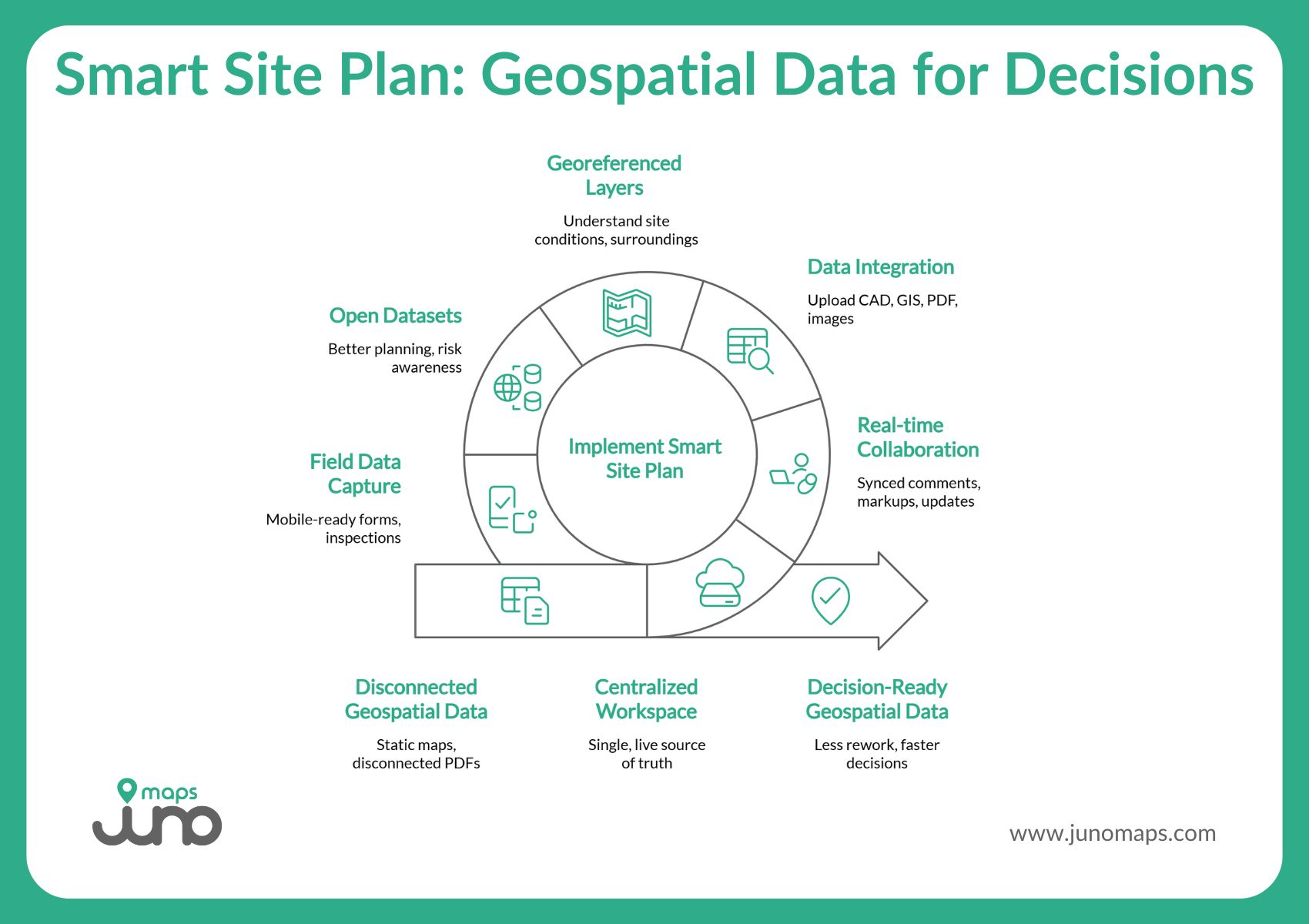
From Images to Decisions: How Smart Site Plan Makes Geospatial Data Work
High-resolution satellite and aerial imagery are only useful if they actually help people do something. Throughout this article, we’ve looked at how imagery becomes meaningful when it’s current, well-layered, and tied to real decisions, whether that’s planning infrastructure, responding to floods or fires, or coordinating work across teams. This is exactly where Smart Site Plan fits into the picture.
Built by Juno Maps, Smart Site Plan is designed to turn imagery, maps, and project files into a shared, decision-ready workspace. Instead of static maps or disconnected PDFs, teams work from a single, live source of truth that travels with them, from the office to the field and back again.
At a glance, Smart Site Plan helps teams:
- Access data anywhere without being tied to a desk or paper plans
- Collaborate in real time with synced comments, markups, and updates
- Upload and view CAD, GIS, PDF, and image files in one centralized map
- Use georeferenced layers to understand site conditions and surroundings
- Tap into millions of open datasets for better planning and risk awareness
- Capture field data on the spot with mobile-ready forms and inspections
The result is less rework, faster decisions, and safer, more informed outcomes, especially when timing and clarity matter most.
See More Clearly. Decide More Confidently.
High-resolution satellite and aerial imagery give teams the ability to understand what’s happening on the ground, but real impact comes from turning that visibility into action. When imagery is current, layered with the right data, and shared across stakeholders, decisions happen faster, coordination improves, and costly mistakes are easier to avoid.
Smart, resilient planning starts with clearer insight and better collaboration. If your team is ready to move beyond static maps and disconnected files, it’s time to see how a shared geospatial workspace can change the way you plan, respond, and build.
Take the next step. Explore Smart Site Plan and start making imagery work for you.
Ready to Put This Into Practice?
See how Juno Maps applies to your specific industry and use case.