Debris Management Guide 2025: Smart Solutions That Work
When a disaster strikes, whether a hurricane, wildfire, flood, tornado, or earthquake, one of the biggest obstacles communities face is the overwhelming volume of debris that clogs roadways, threatens public safety, and stalls recovery. Without a proactive debris management plan in place, communities are left to scramble.
When a disaster strikes, whether a hurricane, wildfire, flood, tornado, or earthquake, one of the biggest obstacles communities face is the overwhelming volume of debris that clogs roadways, threatens public safety, and stalls recovery. Without a proactive debris management plan in place, communities are left to scramble, slowing emergency response, increasing environmental risk, and prolonging displacement and reconstruction. Disaster debris, including vegetation, construction and demolition materials, soil and sediment, hazardous waste, and damaged public infrastructure, is often one of the greatest barriers to rapid recovery.
Key Takeaways
- Pre-disaster assessment: estimate debris volumes (vegetative, construction, hazardous, mixed) to determine staging capacity, manpower, equipment, and processing resources
- Staging and disposal site planning: identify and pre-approve Temporary Debris Management Areas (TDMAs) for storage, processing, or disposal
- Segregation protocols: separate debris streams, including vegetation, construction and demolition waste, hazardous materials, and recyclable materials, for safer, more efficient processing
- Contracting and logistics: establish pre-negotiated contracts with haulers and disposal/recycling facilities; define hauling routes, truck types, load ticketing, and chain-of-custody procedures
- FEMA Public Assistance eligibility requires debris to result from a declared disaster, with a legal obligation to remove it and documentation of costs and quantities
- The Disaster Mitigation Act of 2000 (DMA 2000) encourages jurisdictions to develop long-term hazard mitigation strategies; debris planning is recognized as a critical component
- Smart Site Plan combines disaster imagery, parcel records, and infrastructure layers into one platform for map-based damage and debris assessment with mobile field reporting
Why Debris Management Matters for Community Resilience
Debris that remains unmanaged can obstruct emergency access, prevent damage assessment, delay restoration of utilities, and impede reopening of schools, hospitals, and commercial corridors, slowing economic stabilization and reconstruction efforts.
Debris removal may determine whether recovery takes weeks, months, or years.
The Role of a Debris Management Plan in Faster, Safer Recovery
A debris management plan (or waste-management resource plan) is a structured, proactive framework for how a community prepares for, collects, transports, processes, and disposes of debris after a disaster. It defines roles, responsibilities, resources, and procedures long before anything goes wrong.
The Disaster Mitigation Act of 2000 (DMA 2000) encourages jurisdictions to develop long-term strategies that reduce the impacts of natural hazards and maintain a hazard mitigation plan to remain eligible for certain federal assistance programs. While DMA 2000 and its implementing regulation, 44 CFR Part 201, do not explicitly require jurisdictions to develop a separate, standalone debris management plan, debris planning is widely recognized as a critical component of comprehensive hazard mitigation planning because debris volumes and clearance operations significantly affect recovery speed, public safety, and continuity of operations.
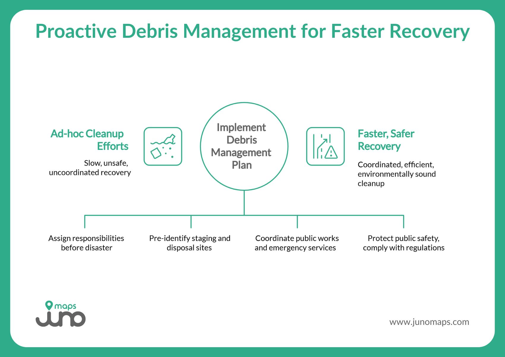
Rather than relying on ad-hoc cleanup efforts, a plan brings coordination across public works, emergency services, utilities, contracting partners, waste management operators, and community stakeholders. It helps mobilize crews, secure contracts, pre-identify staging or disposal sites, and define debris removal operations in a way that protects public safety, complies with environmental regulations, and accelerates recovery.
Key Components of an Effective Debris Management Plan
A strong debris management plan should include:
- Forming a multi-agency debris management steering committee comprised of public works, emergency management, utilities, waste management operators, environmental agencies, and community representatives. This ensures coordination, accountability, and local buy-in.
- Pre-disasterassessment and debris volume projections. Estimate how much debris (vegetative, construction, hazardous, mixed) could be generated by likely disasters in your jurisdiction. This helps determine needed staging capacity, manpower, equipment, and processing resources.
- Staging and disposal site planning. Identify and pre-approve Temporary Debris Management Areas (TDMAs) or other storage, processing, or disposal sites.
- Segregation protocols.Separate debris streams (vegetation, construction and demolition waste, hazardous materials, recyclable materials) for safer, more efficient processing, transport, recycling, or disposal.
- Contracting and logistics plans. Establish pre-negotiated contracts with waste haulers, disposal or recycling facilities, and debris removal crews. Define hauling routes, truck/trailer types, load ticketing, and chain-of-custody procedures.
- Monitoring and documentation procedures. Create a debris monitoring program to track collection, transport, disposal, reduction, or recycling, including load tickets, disposal manifests, volume or tonnage tracking, and responsible parties.
- Waste reduction, recycling, and environmental considerations. Assess which debris streams can be recycled or reused (e.g., clean wood for mulch, salvageable building materials), composted, or treated, rather than landfilled, to reduce environmental impact and landfill burden.
- For hazardous or contaminated debris streams (e.g., asbestos, chemical residues), jurisdictions must ensure compliance with environmental regulations, permits, and specialized disposal procedures.
- Communication and public outreach plan. Inform residents about debris collection operations, safety protocols, temporary debris storage or disposal sites, acceptable waste types, and timeline expectations. Transparency and community buy-in improve safety and efficiency.
- Post-disasterrecovery and long-term monitoring. Track recovery progress, manage reconstruction and rebuilding debris, monitor environmental impacts, and use documented data to update the plan for future events.
According to FEMA’s Public Assistance Debris Management Guide (FEMA 325), communities that develop debris plans in advance are able to implement debris removal operations more efficiently and produce compliant documentation supporting reasonable costs, eligibility, and transparency.
What is debris management?
Debris management is the planning and coordination of debris removal after a disaster or emergency to restore access, protect public safety, and support faster recovery across affected areas.
Why Traditional Debris Management Approaches Are No Longer Enough
Historically, many municipalities and local agencies relied on paper maps, static documents, fragmented spreadsheets, and disconnected datasets, often scattered across departments. When a disaster occurred, these systems failed.
Challenges with older approaches include:
- Lack of shared visibility: Different departments may not know where debris is piling up, which routes are blocked, or which neighborhoods are most affected.
- Delays in field reporting: Inspectors, volunteers, and contractors may face delays or miscommunication in documenting debris, leading to inefficiency.
- Poor tracking and monitoring: Without clear documentation from collection to final disposal, debris removal operations become difficult to audit, inefficient, and environmentally risky.
- Inefficient resource allocation: Without data-driven planning, crews and equipment may not be deployed where they are needed most or may be underused or doubled up elsewhere.
- Environmental and compliance risk: Mixed debris streams, especially hazardous or contaminated waste, may be improperly treated or disposed of, violating regulations and harming the environment.
In an era of more frequent and severe natural disasters, these outdated, disconnected approaches pose serious threats to community resilience, public safety, and environmental health.
Smart Site Plan: The Map-Based Debris Management Software That Simplifies Disaster Debris Operations
As debris, disaster, and waste management become more complex, communities need modern tools that match the challenge. That’s where Smart Site Plan by Juno Maps comes in.
Smart Site Plan is a cloud-based geospatial platform purpose-built for disaster resilience, infrastructure management, public works, utilities, and municipal coordination. It combines mapping, imagery, reporting, and collaboration tools into a single operational environment, allowing jurisdictions to plan ahead, respond faster, and document recovery with clarity and accountability.
Smart Site Plan delivers all the key functionalities that modern debris management demands without requiring GIS expertise.
Originally developed in collaboration with emergency management professionals, Smart Site Plan is actively deployed to support coordinated recovery efforts across regional and local governments, including multiple Planning District Commissions participating in the RISE Riverine Community Resilience Challenge II.
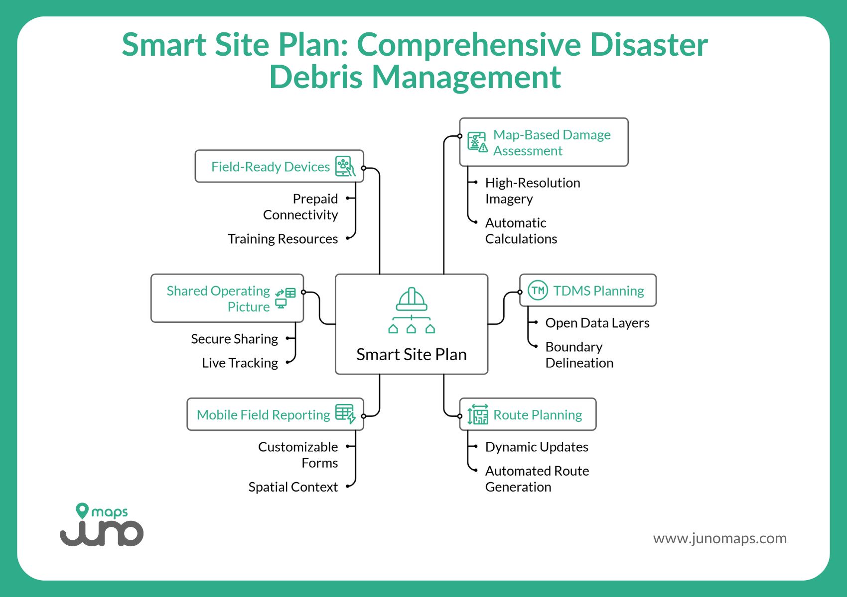
Map-Based Damage and Debris Assessment
Smart Site Plan enables jurisdictions to visualize debris conditions using high-resolution disaster imagery, including open data sources, aerial imagery, PDFs, and tiled drone imagery. Debris piles can be digitized directly on the map, with automatic calculations for area and perimeter, supporting accurate documentation and decision-making from the earliest assessment phase.
Each mapped debris feature can include:
- Debris type and handling priority
- Clearance restrictions and access limitations
- Photos, notes, and supporting documentation
This creates a traceable, defensible record of field observations that supports coordination, reporting, and after-action review.
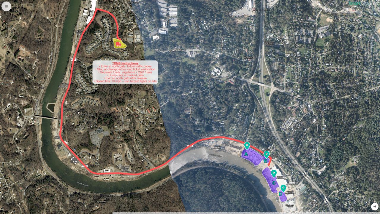
Temporary Debris Management Sites (TDMS) Planning
Smart Site Plan supports identifying and managing Temporary Debris Management Sites (TDMS) during both pre-incident planning and active recovery. Sites can be added using open data layers, uploaded shapefiles, or manual placement on the map. Boundaries can be delineated to define staging areas, collection zones, or disposal limits.
By visualizing TDMS locations alongside impacted areas and transportation networks, jurisdictions can better understand capacity, logistics, and debris flow across the region.
Route Planning and Operational Logistics
Haul routes connecting debris collection areas and TDMS locations can be mapped and updated dynamically as conditions change. These interactive routes support coordinated hauling, detour planning, and clearance prioritization. An automated route-generation capability is currently under development, designed to further optimize debris hauling, evacuation, or detour routes during disaster response.
Mobile Field Reporting and Debris Load Documentation
Smart Site Plan enables electronic debris load tickets and other field forms to be completed directly from the field. These customizable forms align with local, state, or federal reporting requirements and automatically capture time, date, and GPS location, providing a verifiable chain of documentation for debris transport and activity.
Any paper or PDF-based form, including FEMA or state templates, can be converted into secure digital forms, such as:
- Disaster Impact Reports
- Debris Load Tickets
- Damage Assessment Reports
- Resource Request Forms
All submissions are linked to mapped features, ensuring spatial context and consistent reporting across teams.
What role do local governments play in debris management?
Local governments lead preparedness, oversight of contractors, monitoring debris removal operations, and documentation to support safe clearance and environmental compliance.
Shared Operating Picture and Cross-Agency Coordination
Smart Site Plan replaces siloed spreadsheets, emails, and paper maps with a shared, map-based workspace. Debris management plans can be shared securely through read-only links with contractors or partner agencies, allowing stakeholders to view approved information without requiring a platform account.
Interactive maps allow users to:
- See proximity to debris sites and haul routes
- Track progress visually across jurisdictions
- Maintain situational awareness during response and recovery
Live tracking capabilities for vehicles and assets are currently in development to further enhance operational visibility during large-scale debris operations.
Field-Ready Devices, Training, and Ongoing Support
To ensure consistent field capability, participating jurisdictions receive preconfigured, managed iPads equipped with Smart Site Plan and supported through Mobile Device Management (MDM). Devices are field-ready, include prepaid cellular connectivity, and provide direct access to reporting tools, training resources, and live support.
Training is focused on practical application, not theory. Emergency management staff receive guidance tailored to debris workflows, documentation requirements, and operational use. Ongoing training and in-platform help resources ensure teams can adapt and improve over time.
A Living Framework for Debris Management
By integrating mapping, imagery, mobile reporting, and collaboration, Smart Site Plan supports debris management from assessment through clearance, hauling, and disposal. More importantly, it creates a living debris management framework that evolves with changing hazards, infrastructure conditions, and community needs.
Smart Site Plan doesn’t just help communities respond faster; it strengthens transparency, improves accountability, and builds long-term operational capacity for disaster recovery.
How does geospatial intelligence support emergency debris planning?
Geospatial intelligence integrates hazard data, infrastructure locations, and debris impacts into a single map, strengthening preparedness and enabling targeted response.
Smarter Debris Management Begins With Better Planning
Debris removal is more than cleanup; it is a critical emergency management activity that determines how quickly communities reopen, restore services, and return residents to safety and stability. According to DMA 2000 and supporting guidance under 44 CFR Part 201, long-term hazard reduction strategies must be planned before disaster strikes, and debris management is central to that mission.
The most resilient communities act early. They build plans, modernize systems, practice coordination, and leverage technology long before debris piles up.
If your jurisdiction is preparing to strengthen its debris management operations, now is the time to adopt smarter tools, more connected data, and actionable mapping intelligence.
Learn how Juno Maps helps communities remove debris faster, safer, and with stronger accountability, so recovery begins immediately, not weeks later. Get in touch for more information!
Ready to Put This Into Practice?
See how Juno Maps applies to your specific industry and use case.