Floodplain Management and Flood Resilience Software for Local Governments
Smart Site Plan integrates FEMA NFHL flood hazard layers with parcel records, utility infrastructure, and real-time field reporting, giving floodplain managers and emergency coordinators the data they need to act before the water rises and document losses after it recedes.
Flood Risk Is Escalating, Outdated Data Cannot Keep Pace
Riverine and coastal communities across the United States face more frequent and severe flood events, driven by aging stormwater infrastructure, upstream land-use changes, and shifting precipitation patterns. The consequences extend well beyond property damage: displaced residents, disrupted utility service, and years of deferred recovery compound the long-term fiscal burden on local governments.
Smart Site Plan by Juno Maps provides floodplain managers, public works directors, and emergency coordinators with a cloud-based GIS platform that unifies FEMA NFHL flood zones, parcel-level exposure data, and infrastructure records, enabling faster, evidence-based decisions at every phase of the flood lifecycle.
Get StartedGIS-Powered Support Across the Full Flood Lifecycle
From pre-event floodplain management through FEMA Public Assistance documentation, Smart Site Plan equips your team with actionable tools at every phase.
Preparedness
- Visualize FEMA Special Flood Hazard Areas (SFHAs), 500-year floodplains, and low-lying risk areas using NFHL-integrated topographic overlays
- Identify vulnerable infrastructure, stormwater systems, water mains, pump stations, using high-resolution imagery and utility data
- Compare multi-year historical imagery to detect channel migration, sediment buildup, and floodplain encroachment
- Sketch and document mitigation alternatives including flood barriers, green infrastructure, and structure elevations to support HMGP and BRIC applications
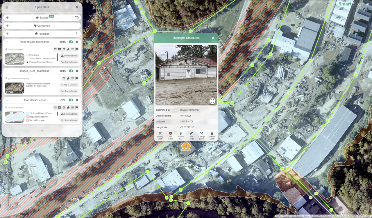
Response
- Publish real-time flood zone maps, road closure overlays, and shelter locations to residents and mutual aid partners, no login required for public access
- Deploy mobile damage assessment forms to field teams for geo-tagged photo capture, structure loss documentation, and needs assessments
- Coordinate EOC staff, public works crews, and state liaisons from a shared, property-linked operational platform aligned with ICS/NIMS protocols
Recovery
- Quantify flood damage at the parcel level with georeferenced measurements and preliminary cost estimates to accelerate FEMA Public Assistance submissions
- Produce georeferenced damage reports and hazard risk maps to support FEMA IA/PA claims, HUD CDBG-DR applications, and state disaster grants
- Distribute damage summaries and recovery progress updates via public share links accessible to residents, insurance adjusters, and oversight agencies without requiring accounts

Built for the Operational Demands of Flood Management
Integrates FEMA NFHL, national parcel data, USGS elevation products, and hundreds of open federal datasets in a single browser-based platform
No GIS license or specialist required, intuitive sketch-based tools accessible to floodplain administrators, public works staff, and elected officials
Configured for NFIP compliance, CRS credit documentation, post-disaster reporting, and infrastructure capital planning
Shareable maps and exportable reports for FEMA reviewers, state agency partners, oversight boards, and public stakeholders
Flood Management Technical Resources
Guidance on FEMA flood map interpretation, floodplain mitigation planning, CRS participation, and GIS-based damage assessment for local governments and water resource agencies.
Protect Your Community from Flood Risk
Contact our team to learn how Smart Site Plan supports NFIP compliance, CRS credit documentation, HMGP applications, and post-flood FEMA Public Assistance for municipalities and county governments.